From March 2016 onwards, Dr. Markus Neteler, a prominent head of the Open Source GIS scene, will join the management board of mundialis GmbH & Co. KG in Bonn, Germany. Founded in 2015, mundialis combines remote sensing and satellite data analysis in the field of Big Data with Open Source WebGIS solutions.
Since 2008, Dr. Neteler was the head of the GIS and remote sensing unit at the Edmund Mach Foundation in Trento (Italy) and worked in this capacity on numerous projects related to biodiversity, environmental and agricultural research. He is also a founding member of the Open Source Geospatial Foundation (OSGeo), a nonprofit organization with headquarters in Delaware (USA), that promotes the development and use of free and open source geographic information systems (GIS). Since 1998 he coordinated the development of the well known GRASS GIS software project, a powerful Open Source GIS that supports processing of time series of several thousand raster, 3D raster or vector maps in a short time.
Markus will keep his role as “Mr. GRASS” at mundialis, especially because the company also sees itself as a research and development enterprise that puts its focus on the open source interfaces between geoinformation and remote sensing. Although a new company, mundialis offers more than 50 years of experience in GIS, due to the background of its management. Besides Neteler, there are Till Adams and Hinrich Paulsen, both at the same time the founders and CEOs of terrestris in Bonn, a company that develops Open Source GIS solutions since 2002. These many years of experience in the construction of WebGIS and Geoportal architectures using free software as well as in the application of common OGC standards – are now combined with mundialis’ expertise in the processing of big data with spatial reference and remote sensing data.
https://neteler.org/wp-content/uploads/2024/01/wg_neteler_logo.png00Markushttps://neteler.org/wp-content/uploads/2024/01/wg_neteler_logo.pngMarkus2016-01-25 18:06:482023-11-03 23:12:00Markus Neteler joins the management of mundialis in Bonn
The new GRASS GIS 7.0.2 release provides 190 stability fixes and manual improvements.
About GRASS GIS 7: Its graphical user interface supports the user to make complex GIS operations as simple as possible. The updated Python interface to the C library permits users to create new GRASS GIS-Python modules in a simple way while yet obtaining powerful and fast modules. Furthermore, the libraries were significantly improved for speed and efficiency, along with support for huge files. A lot of effort has been invested to standardize parameter and flag names. Finally, GRASS GIS 7 comes with a series of new modules to analyse raster and vector data, along with a full temporal framework. For a detailed overview, see the list of new features. As a stable release series, 7.0.x enjoys long-term support.
The Geographic Resources Analysis Support System (https://grass.osgeo.org/), commonly referred to as GRASS GIS, is an Open Source Geographic Information System providing powerful raster, vector and geospatial processing capabilities in a single integrated software suite. GRASS GIS includes tools for spatial modeling, visualization of raster and vector data, management and analysis of geospatial data, and the processing of satellite and aerial imagery. It also provides the capability to produce sophisticated presentation graphics and hardcopy maps. GRASS GIS has been translated into about twenty languages and supports a huge array of data formats. It can be used either as a stand-alone application or as backend for other software packages such as QGIS and R geostatistics. It is distributed freely under the terms of the GNU General Public License (GPL). GRASS GIS is a founding member of the Open Source Geospatial Foundation (OSGeo).
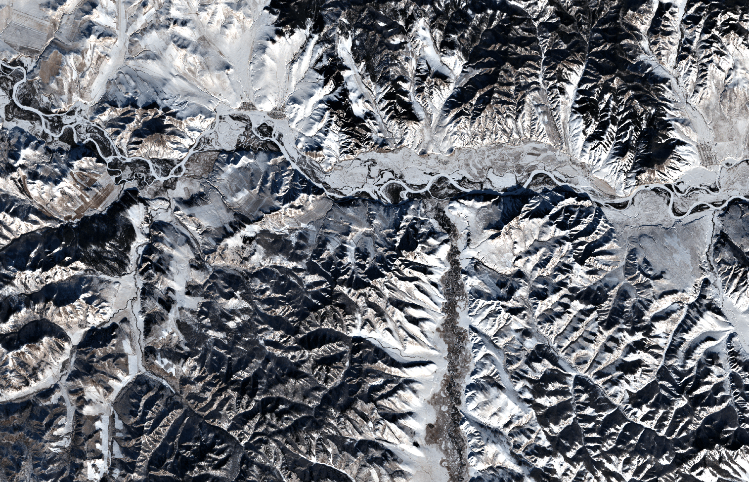
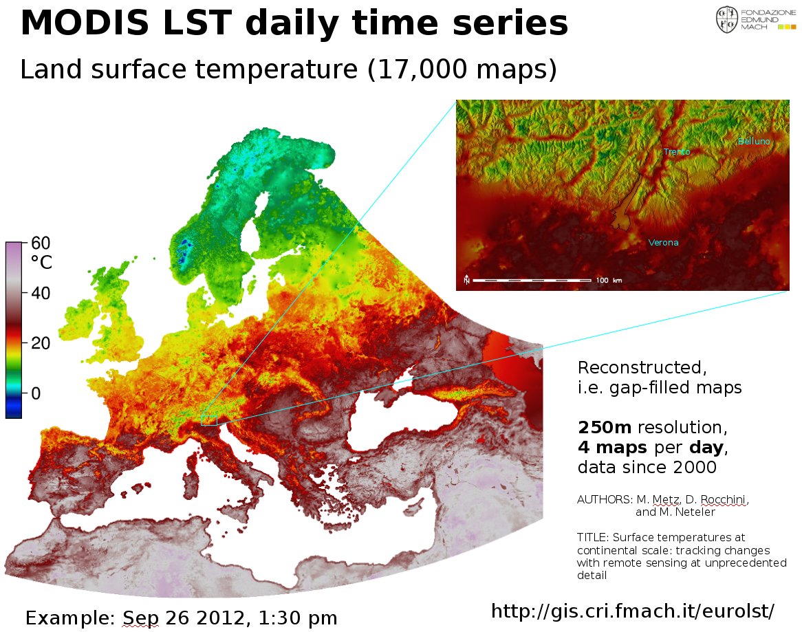
The EuroLST dataset is seamless and gap-free with a temporal resolution of four records per day and enhanced spatial resolution of 250 m. This newly developed reconstruction method (Metz et al, 2014) has been applied to Europe and neighbouring countries, resulting in complete daily coverage from 2001 onwards. To our knowledge, this new reconstructed LST time series exceeds the level of detail of comparable reconstructed LST datasets by several orders of magnitude. Studies on emerging diseases, parasite risk assessment and temperature anomalies can now be performed on the continental scale, maintaining high spatial and temporal detail. In their paper, the authors provide examples for implications and applications of the new LST dataset, such as disease risk assessment, epidemiology, environmental monitoring, and temperature anomalies.
Reconstructed MODIS Land Surface Temperature Dataset, at 250m pixel resolution (click figure to enlarge):
MODIS Land Surface Temperature (LST) reconstructed (gap-filled)
Article and data citation:
EuroLST has been produced by the former PGIS group at Fondazione Edmund Mach, DBEM based on daily MODIS LST (Product of NASA) maps.
Metz, M.; Rocchini, D.; Neteler, M. 2014: Surface temperatures at the continental scale: Tracking changes with remote sensing at unprecedented detail. Remote Sensing. 2014, 6(5): 3822-3840 (DOI | HTML | PDF)
Used software
Open Source commands used in processing (GRASS GIS 7):
links to the related manual pages involved in the data preparation
i.pca: Principal Components Analysis (PCA) for image processing.
r.regression.multi: it calculates multiple linear regression from raster maps
v.surf.bspline: it performs bicubic or bilinear spline interpolation with Tykhonov regularization.
Furthermore:
r.bioclim: calculates various bioclimatic indices from monthly temperature and optional precipitation time series (install in GRASS GIS 7 with “g.extention r.bioclim”)
pyModis: Free and Open Source Python based library to work with MODIS data
BIOCLIM derived from reconstructed MODIS LST at 250m pixel resolution
BIOCLIM-like European LST maps following the “Bioclim” definition (Hutchinson et al., 2009) – derived from 10 years of reconstructed MODIS LST (download to be completed) as GeoTIFF files, 250m pixel resolution, in EU LAEA projection:
Each ZIP file contains the respective GeoTIFF file (for cell value units, see below), the color table as separate ASCII file and a README.txt with details.
WMS/WCS Server
Using this URL, you can read the EuroLST BIOCLIM data directly via OGC WMS and WCS protocol:
The data published in this page are open data and released under the ODbL (Open Database License).
The full EuroLST dataset is not released online as open data (size: 18TB), please ask Luca Delucchi or Roberto Zorer for more info
Acknowledgments
The MOD11A1.005, MYD11A1.005 were retrieved from the online web site, courtesy of the NASA EOSDIS Land Processes Distributed Active Archive Center (LP DAAC), USGS/Earth Resources Observation and Science (EROS) Center, Sioux Falls, South Dakota, https://e4ftl01.cr.usgs.gov/
https://neteler.org/wp-content/uploads/2024/01/wg_neteler_logo.png00Markushttps://neteler.org/wp-content/uploads/2024/01/wg_neteler_logo.pngMarkus2015-09-13 18:01:252024-01-25 22:49:48The EuroLST seamless and gap-free daily European maps of land surface temperatures
This release addresses some minor issues found in the first GRASS GIS 7.0.0 release published earlier this year. The new release provides a series of stability fixes in the core system and the graphical user interface, PyGRASS improvements, some manual enhancements, and a few language translations.
This release is the 32nd birthday release of GRASS GIS.
New in GRASS GIS 7: Its new graphical user interface supports the user in making complex GIS operations as simple as possible. A new Python interface to the C library permits users to create new GRASS GIS-Python modules in a simple way while yet obtaining powerful and fast modules. Furthermore, the libraries were significantly improved for speed and efficiency, along with support for huge files. A lot of effort has been invested to standardize parameter and flag names. Finally, GRASS GIS 7 comes with a series of new modules to analyse raster and vector data, along with a full temporal framework. For a detailed overview, see the list of new features. As a stable release 7.0 enjoys long-term support.
The Geographic Resources Analysis Support System (https://grass.osgeo.org/), commonly referred to as GRASS GIS, is an Open Source Geographic Information System providing powerful raster, vector and geospatial processing capabilities in a single integrated software suite. GRASS GIS includes tools for spatial modeling, visualization of raster and vector data, management and analysis of geospatial data, and the processing of satellite and aerial imagery. It also provides the capability to produce sophisticated presentation graphics and hardcopy maps. GRASS GIS has been translated into about twenty languages and supports a huge array of data formats. It can be used either as a stand-alone application or as backend for other software packages such as QGIS and R geostatistics. It is distributed freely under the terms of the GNU General Public License (GPL). GRASS GIS is a founding member of the Open Source Geospatial Foundation (OSGeo).
https://neteler.org/wp-content/uploads/2024/01/wg_neteler_logo.png00Markushttps://neteler.org/wp-content/uploads/2024/01/wg_neteler_logo.pngMarkus2015-07-31 20:20:162023-10-22 18:58:12GRASS GIS 7.0.1 released – 32 years of GRASS GIS
Thanks to the work of Volker Fröhlich and other Fedora/EPEL packagers I was able to create RPM packages of QGIS 2.10 Pisa for Fedora 21, Centos 7, and Scientific Linux 7 using the great COPR platform.
The Open Source Geospatial Foundation would like to open nominations for the 2015 Sol Katz Award for Geospatial Free and Open Source Software.
The Sol Katz Award for Geospatial Free and Open Source Software (GFOSS) will be given to individuals who have demonstrated leadership in the GFOSS community. Recipients of the award will have contributed significantly through their activities to advance open source ideals in the geospatial realm.
Sol Katz was an early pioneer of GFOSS and left behind a large body of work in the form of applications, format specifications, and utilities while at the U.S. Bureau of Land Management. This early GFOSS archive provided both source code and applications freely available to the community. Sol was also a frequent contributor to many geospatial list servers, providing much guidance to the geospatial community at large.
Sol unfortunately passed away in 1999 from Non-Hodgkin’s Lymphoma, but his legacy lives on in the open source world. Those interested in making a donation to the American Cancer Society, as per Sol’s family’s request, can do so at https://donate.cancer.org/index.
The winner of the Sol Katz Award for Geospatial Free and Open Source Software will be announced at the FOSS4G-Seoul event in September. The hope is that the award will both acknowledge the work of community members, and pay tribute to one of its founders, for years to come.
It should be noted that past awardees and selection committee members are not eligible.
2014: Gary Sherman
2013: Arnulf Christl
2012: Venkatesh Raghavan
2011: Martin Davis
2010: Helena Mitasova
2009: Daniel Morissette
2008: Paul Ramsey
2007: Steve Lime
2006: Markus Neteler
2005: Frank Warmerdam
Selection Committee 2015:
Jeff McKenna (chair)
Frank Warmerdam
Markus Neteler
Steve Lime
Paul Ramsey
Sophia Parafina
Daniel Morissette
Helena Mitasova
Martin Davis
Venkatesh Raghavan
Arnulf Christl
Gary Sherman
https://neteler.org/wp-content/uploads/2024/01/wg_neteler_logo.png00Markushttps://neteler.org/wp-content/uploads/2024/01/wg_neteler_logo.pngMarkus2015-07-23 22:54:052023-10-22 18:57:37Sol Katz Award – Call for Nominations
Sometimes, we developers get reports via mailing list that this & that would not work on whatever operating system. Now what? Should we be so kind and install the operating system in question in order to reproduce the problem? Too much work… but nowadays it has become much easier to perform such tests without having the need to install a full virtual machine – thanks to docker.
Disclaimer: I don’t know much about docker yet, so take the code below with a grain of salt!
In my case I usually work on Fedora or Scientific Linux based systems. In order to quickly (i.e. roughly 10 min of automated installation on my slow laptop) try out issues of GRASS GIS 7 on e.g., Ubuntu, I can run all my tests in docker installed on my Fedora box:
# we need to run stuff as root user
su
# Fedora 21: install docker
yum -y docker-io

# Fedora 22: install docker
dnf -y install docker

# enable service
systemctl start docker
systemctl enable docker
Now we have a running docker environment. Since we want to exchange data (e.g. GIS data) with the docker container later, we prepare a shared directory beforehand:
# we'll later map /home/neteler/data/docker_tmp to /tmp within the docker container
mkdir /home/neteler/data/docker_tmp
Now we can start to install a Ubuntu docker image (may be “any” image, here we use “Ubuntu trusty” in our example). We will share the X11 display in order to be able to use the GUI as well:
# enable X11 forwarding
xhost +local:docker

# search for available docker images
docker search trusty

# fetch docker image from internet, establish shared directory and display redirect
# and launch the container along with a shell
docker run -v /data/docker_tmp:/tmp:rw -v /tmp/.X11-unix:/tmp/.X11-unix \
       -e uid=$(id -u) -e gid=$(id -g) -e DISPLAY=unix$DISPLAY \
       --name grass70trusty -i -t corbinu/docker-trusty /bin/bash
In almost no time we reach the command line of this minimalistic Ubuntu container which will carry the name “grass70trusty” in our case (btw: read more about Working with Docker Images):
root@8e0f233c3d68:/#
# now we register the Ubuntu-GIS repos and get GRASS GIS 7.0
add-apt-repository ppa:ubuntugis/ubuntugis-unstable
add-apt-repository ppa:grass/grass-stable
apt-get update
apt-get install grass7
This will take a while (the remaining 9 minutes or so of the overall 10 minutes).
Since I like cursor support on the command line, I launch (again?) the bash in the container session:
root@8e0f233c3d68:/# bash
# yes, we are in Ubuntu here
root@8e0f233c3d68:/# cat /etc/issue
Now we can start to use GRASS GIS 7, even with its graphical user interface from inside the docker container:
# create a directory for our data, it is mapped to /home/neteler/data/docker_tmp/
# on the host machine
root@8e0f233c3d68:/# mkdir /tmp/grassdata
# create a new LatLong location from EPSG code
# (or copy a location into /home/neteler/data/docker_tmp/)
root@8e0f233c3d68:/# grass70 -c epsg:4326 ~/grassdata/latlong_wgs84
# generate some data to play with
root@8e0f233c3d68:/# v.random n=30 output=random30
# start the GUI manually (since we didn't start GRASS GIS right away with it before)
root@8e0f233c3d68:/# g.gui
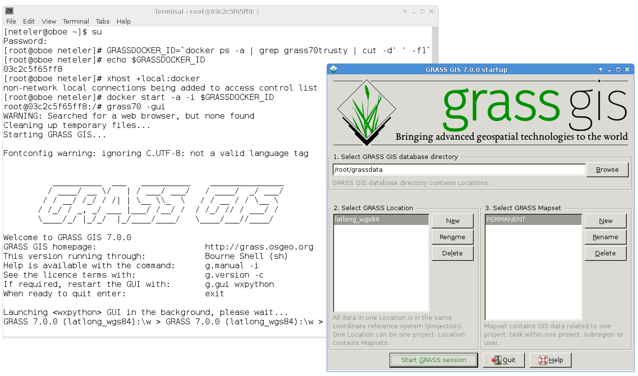
Indeed, the GUI comes up as expected!
GRASS GIS 7 GUI in docker container
You may now perform all tests, bugfixes, whatever you like and leave the GRASS GIS session as usual.
To get out of the docker session:
root@8e0f233c3d68:/# exit    # leave the extra bash shell
root@8e0f233c3d68:/# exit    # leave docker session

# disable docker connections to the X server
[root@oboe neteler]# xhost -local:docker
To restart this session later again, you will call it with the name which we have earlier assigned:
[root@oboe neteler]# docker ps -a
# ... you should see "grass70trusty" in the output in the right column

# we are lazy and automate the start a bit
[root@oboe neteler]# GRASSDOCKER_ID=`docker ps -a | grep grass70trusty | cut -d' ' -f1`
[root@oboe neteler]# echo $GRASSDOCKER_ID
[root@oboe neteler]# xhost +local:docker
[root@oboe neteler]# docker start -a -i $GRASSDOCKER_ID

### ... and so on as described above.
https://neteler.org/wp-content/uploads/2024/01/wg_neteler_logo.png00Markushttps://neteler.org/wp-content/uploads/2024/01/wg_neteler_logo.pngMarkus2015-04-12 00:30:102023-11-11 19:07:57Fun with docker and GRASS GIS software
To get the GRASS GIS 6.4.5RC1 source code directly from SVN:
svn checkout https://svn.osgeo.org/grass/grass/tags/release_20150406_grass_6_4_5RC1/
Key improvements:
Key improvements of the GRASS GIS 6.4.5RC1 release include stability fixes (esp. vector library), some fixes for wxPython3 support, some module fixes, and more message translations.
The Geographic Resources Analysis Support System (https://grass.osgeo.org), commonly referred to as GRASS GIS, is an Open Source Geographic Information System providing powerful raster, vector and geospatial processing capabilities in a single integrated software suite. GRASS GIS includes tools for spatial modeling, visualization of raster and vector data, management and analysis of geospatial data, and the processing of satellite and aerial imagery. It also provides the capability to produce sophisticated presentation graphics and hardcopy maps. GRASS GIS has been translated into about twenty languages and supports a huge array of data formats. It can be used either as a stand-alone application or as backend for other software packages such as QGIS and R geostatistics. It is distributed freely under the terms of the GNU General Public License (GPL). GRASS GIS is a founding member of the Open Source Geospatial Foundation (OSGeo).
Thanks to the work of Devrim Gündüz, Volker Fröhlich, Dave Johansen, Rex Dieter and other Fedora/EPEL packagers I had an easy going to prepare RPM packages of QGIS 2.8 Wien for Fedora 20 and 21, Centos 7, and Scientific Linux 7.
The base SRPM package I copied from Fedora’s koji server, modified the SPEC file in order to remove the now outdated PyQwt bindings (see bugzilla) and compiled QGIS 2.8 via the great COPR platform.
The Orfeo ToolBox (OTB), an open-source C++ library for remote sensing images processing, is offering a wealth of algorithms to perform Image manipulation, Data pre-processing, Features extraction, Image Segmentation and Classification, Change detection, Hyperspectral processing, and SAR processing.
Since there is no (fresh) RPM package available for Centos or Scientific Linux, here some quick hints (no full tutorial, though) how to get OTB easily locally compiled. We are following the Installation Chapter.
Importantly, you need to have some libraries installed including GDAL. Be sure that it has been compiled with the “–with-rename-internal-libtiff-symbols” and ” –with-rename-internal-libgeotiff-symbols” flags to avoid namespace collision a.k.a segmentation fault of OTB as per “2.2.4 Building your own qualified Gdal“. We’ll configure and build with the GDAL-internal Tiff and Geotiff libraries that supports BigTiff files
# configure GDAL
./configure \
 --without-libtool \
 --with-geotiff=internal --with-libtiff=internal \
 --with-rename-internal-libtiff-symbols=yes \
 --with-rename-internal-libgeotiff-symbols=yes \
...
make
make install
The compilation of the OTB source code requires “cmake” and some other requirements which you can install via “yum install …”. Be sure to have the following structure for compiling OTB, i.e. store the source code in a subdirectory. The binaries will then be compiled in a “build” directory parallel to the OTB-SRC directory:
Now it is time to configure everything for OTB. Since I didn’t want to bother with “ccmake”, below the magic lines to compile and install OTB into its own subdirectory within /usr/local/. We’ll use as many internal libraries as possible according to the table in the installation guide. The best way is to save the following lines as a text script “cmake_otb.sh” for easier (re-)use, then run it:
#!/bin/sh

OTBVER=4.4.0
(
mkdir -p build
cd build

cmake -DCMAKE_INSTALL_PREFIX:PATH=/usr/local/otb-$OTBVER \
      -DOTB_USE_EXTERNAL_ITK=OFF -DOTB_USE_EXTERNAL_OSSIM=OFF \
      -DOTB_USE_EXTERNAL_EXPAT=OFF -DOTB_USE_EXTERNAL_BOOST=OFF \
      -DOTB_USE_EXTERNAL_TINYXML=OFF -DOTB_USE_EXTERNAL_LIBKML=OFF \
      -DOTB_USE_EXTERNAL_MUPARSER=OFF \
       ../OTB-SRC/

make -j4
# note: we assume to have write permission in /usr/local/otb-$OTBVER
make install
)
That’s it!
In order to use the freshly compiled OTB, be sure to add the new directories for the binaries and the libraries to your PATH and LD_LIBRARY_PATH variables, e.g. in $HOME/.bashrc:
https://neteler.org/wp-content/uploads/2024/01/wg_neteler_logo.png00Markushttps://neteler.org/wp-content/uploads/2024/01/wg_neteler_logo.pngMarkus2015-02-25 22:18:492023-10-22 18:55:38Compiling OTB Orfeo ToolBox software on Centos/Scientific Linux